Oct.15, 2019

台風19号の脅威


台風19号は「非常に強い」勢力で12日(土)午後に東海や関東に上陸の恐れ。関西空港が浸水した昨年の台風21号に匹敵する勢力です。」

●台風19号 非常に強い勢力で上陸か

台風19号はあまり勢力を落とさず、12日(土)午後に「非常に強い」勢力で東海や関東に上陸する恐れがあります。台風の勢力とは中心付近の最大風速で決まり、「非常に強い」とは強い方から2番目の勢力です。

「非常に強い」勢力で日本列島に上陸する台風はそうそうありません。2018年台風21号は記憶に新しいところですが、その前は1993年台風13号まで遡ります。

●非常に強い勢力で上陸した2018年台風21号

昨年の台風21号は「非常に強い」勢力で徳島県南部に上陸し、近畿地方を縦断しました。四国や近畿地方で猛烈な風が吹き、猛烈な雨が降ったほか、顕著な高潮となった所もありました。関西空港では 最大瞬間風速58.1メートルを観測し、観測史上1位となりました。また、最高潮位が大阪府大阪市では329センチメートル、兵庫県神戸市では233センチメートルなど、過去の最高潮位を超える値を観測。関西空港の滑走路や駐機場が広い範囲で浸水するなどの被害がでました。総降水量が四国地方や近畿地方、東海地方で300ミリを超えた所もあるなど、大きな影響がでました。

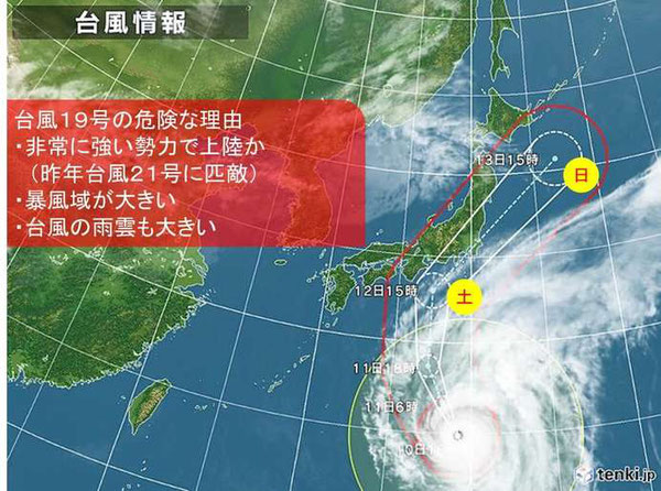
●台風19号の危険な理由

今回の台風19号が危険な理由は「非常に強い」勢力で上陸するということだけではありません。ほかにも「暴風域が大きい」ため、広い範囲で、半日程度と長い時間、暴風が吹き荒れる恐れがあります。瞬間的には50メートル以上の猛烈な風が吹く可能性もあります。また、台風を取り巻く活発な「雨雲が大きい」ことも危険な理由です。半日以上と長い時間、強い雨が降り続く見込みです。湿った空気の影響で台風の接近前から雨が降り、総雨量がかなり多くなるでしょう。

四国から関東では11日(金)午後から風や雨が強まりはじめそうです。12日(土)の午後から13日(日)の午前中が暴風や大雨のピークとなりそうです。猛烈な風が吹き荒れる恐れがあり、外出は危険な状態となります。関東や東海、紀伊半島などで500ミリ以上の記録的な大雨となる恐れもあります。大荒れの天気が夜間なため、自治体から出される避難情報に注意し、明るいうちに早めの避難を心がけて下さい。13日(日)は東北でも大荒れの天気となるでしょう。飛ばされやすいものは固定したり、室内にしまう、停電に備えて、懐中電灯や非常食、飲料水を準備しておく、スマートフォンなどもあらかじめ充電しておくなど、早め早めの対策をして下さい。

また、海上は猛烈なしけとなるため、海岸付近には近づかないようにして下さい。大潮の時期にあたり、台風の接近と満潮時刻が重なるとさらに潮位が高くなる恐れがあります。高潮にも厳重な警戒が必要です。


台風19号の進路 関東に最悪 記録的な大雨や暴風も

Japan Weather Association 提供 台風19号の進路 関東に最悪 記録的な大雨や暴風も

台風19号は「大雨特別警報」発表の可能性があり、「狩野川台風」に匹敵する恐れも。関東にとっては最悪の進路を通り、記録的な暴風や大雨となる所もありそうです。

●台風19号 関東に「最悪なコース」の理由

12日(土)から13日(日)にかけて、列島を襲う台風19号。今回の予想進路は、関東にとって最悪なコースとなりそうです。予報円(台風の中心が70%の確率で入ると予想される範囲)をみてみますと、今回の台風は、東海地方や関東地方に上陸する可能性が高くなっています。

ただ、台風は進行方向の「右側」で、特に風が強くなります。というのも、台風の進行方向の右側は、中心に向かって「反時計回りに吹き込む風」と、「台風自体を動かしている風」との2つが、同じ方向になって合わさるからです。今回の台風19号は、予想されている進路の中で、最も西側のコースを通った場合、15号の被害が残っている千葉県だけでなく、関東のほぼ全域が台風の進行方向の「右側」に入ってしまいそうです。

12日までに予想されている最大瞬間風速は、関東甲信地方や東海地方で60m/sです。台風15号の時に、千葉市で観測された最大瞬間風速は57.5m/sですから、15号と同じか、更に強い風が吹き荒れて、記録的な暴風になる恐れがあるのです。

記録的な暴風だけでなく 記録的な大雨も

また、台風は、反時計回りに風が吹くので、関東を北東方面に進んだ場合、南東~東から吹き込む風が多摩や秩父など関東の西側の山にぶつかり続けて、雨雲が次々に発生する恐れがあります。さらに台風19号は、「暴風域が広い」こともポイントです。このため「風の吹き荒れる時間」が「長く」なってしまい、暴風が長引くだけでなく、活発な雨雲も長い時間かかりつづけることで、総雨量が多くなる恐れがあります。

予想雨量(いずれも多い所)は、関東甲信地方では、12日12時までの24時間に250ミリ、さらに13日12時までの24時間に300~500ミリ。東海地方では、12日12時までの24時間に500ミリ、さらに13日12時までの24時間に600~800ミリと、トータルでは、1000ミリを超えて、記録的な大雨になる可能性もあるのです。

●1200人以上が犠牲「狩野川台風」に 匹敵する恐れも

かつて、首都圏に大きな被害をもたらした台風といえば、昭和33年(1958年)の狩野川台風がありました。この台風では、特に東海地方や関東地方で大雨になり、1200人以上が犠牲になったり、土砂災害が多発し、川の氾濫が相次ぐなど、大きな被害をもたらしました。

今回の台風19号は、この狩野川台風に匹敵する記録的な大雨となる恐れがあります。また、気象庁によりますと、状況によっては、大雨による「特別警報」が発表される可能性もあります。

雨や風が強まる前に、まだ明るい時間帯のうちに、なるべく早い避難や安全を確保するよう、心がけて下さい。


National

Powerful Typhoon Hagibis makes landfall over Izu Peninsula after prompting rare weather warning

by Ryusei Takahashi Staff Writer

Record-breaking rainfall, strong winds and severe flooding befell areas from central to northern Japan on Saturday as one of the strongest typhoons to hit the country in years made landfall over Shizuoka Prefecture’s Izu Peninsula.

The massive Typhoon Hagibis was lashing wide areas of the nation, prompting evacuation advisories for hundreds of thousands of people.


Officials in Tokyo and surrounding areas, including Tokyo’s Edogawa Ward, the city of Kawasaki and many other municipalities in Kanagawa Prefecture, warned of flood risks as rivers rose and advised evacuation.

Heavy rains caused by Typhoon Hagibis flood a residential area in Ise, Mie Prefecture. | KYODO


A level 5 special warning for heavy rain, the highest issued by the Meteorological Agency, was issued at 3:30 p.m. on Saturday urging residents in Tokyo, Shizuoka, Kanagawa, Saitama, Gunma, Yamanashi and Nagano prefectures to evacuate to a secure building or move to the second floor.

The Kanagawa Prefectural Government announced that it may have to release water from Shiroyama Dam in Sagamihara later in the day as an emergency measure to lower the water level.

That move would push up the water levels in the Sagami River and some rivers connected to it, significantly increasing flood risks in some areas in Sagamihara, Hiratsuka, Chigasaki, Atsugi, Ebina, Zama, Samukawa and Aikawa in the prefecture, officials said.

This house and car are believed to have been wrecked by a tornado in Ichihara, Chiba Prefecture, on Saturday morning. | KYODO


Amid concerns about landslides, flooding and record-breaking rainfall, more than 188,000 residents in Hachioji — a city in the western part of the greater Tokyo metropolitan area — and 432,000 in Edogawa Ward were issued an evacuation advisory, which is the last warning issued before a noncompulsory evacuation instruction is given.

In the city of Ichihara in Chiba Prefecture — which was still recovering after it took the brunt of Typhoon Faxai last month — a man was killed at around 9:30 a.m. on Saturday when his vehicle flipped over, while four others—including two children — were injured by a tornado in a nearby area. Some 9,200 households in and around Chiba Prefecture lost power at 9:30 a.m. Saturday morning along with about 200 households across Tokyo, and Ibaraki and Shizuoka prefectures.

Surging waves hit against the breakwater behind fishing boats as Typhoon Hagibis approaches at the port in the town of Kiho, Mie Prefecture on Saturday. | AP


Hagibis, which on Saturday evening was considered equivalent to a Category 4 hurricane on the five step Saffir-Simpson scale used in the United States, drew comparisons to a deadly 1958 typhoon in Shizuoka Prefecture and the Kanto region that triggered a series of landslides and flooded the Kano River, leaving 888 people dead 381 missing.

Hagibis was predicted to attain average windspeeds of 162 kilometers per hour and drop 500 millimeters of rainfall in the Kanto-Koshin region. Hagibis was passing over several areas still trying to recover from Faxai, which wreaked havoc just over a month ago, killing at least three people and injuring around 40.

Most forms of public transportation, including trains and planes, were suspended or canceled on Saturday. East Japan Railway Co. (JR East) announced on Friday that several trains would be suspended on Saturday. The Shonan-Shinjuku Line was halted for the entire day while other major routes including the Chuo, Yamanote, Saikyo and Keihin Tohoku lines were suspended at around noon.

A woman puts masking tape on windows in preparation for the typhoon in Kyonan, Chiba Prefecture, on Friday. | KYODO


Central Japan Railway Co. (JR Central) canceled all shinkansen services between Tokyo and Nagoya on Saturday while West Japan Railway Co. (JR West) suspended various lines between Shin-Osaka and Okayama stations from the afternoon onward.

Two rugby matches set to be played at Nissan Stadium in Yokohama and Toyota Stadium in Aichi Prefecture were canceled on Saturday for the first time in Rugby World Cup history. The storm also forced the first-ever all-day closure of Tokyo’s Disneyland and DisneySea theme parks, disrupted the Suzuka Grand Prix and grounded more than 1,600 flights.


© KYODONEWS 台風19号で増水し、千曲川(右側)の堤防が決壊した現場。住宅地に濁流が流れ込んだ=13日午後、長野市穂保(小型無人機から)

 台風19号、10県の26人死亡 21人不明、10河川で堤防決壊

 東日本を縦断し、13日に温帯低気圧に変わった台風19号による猛烈な雨の影響で、長野県の千曲川など10河川の12カ所で堤防が決壊し、住宅地などをのみ込む大規模な洪水被害が各地で発生した。土砂災害も相次ぎ、共同通信の集計で10県の26人が死亡し、21人が行方不明となった。負傷者も多数に上った。孤立状態になった地域も多く、警察や消防のほか、災害派遣要請を受けた自衛隊が捜索や救助を行った。

 国土交通省によると、長野市穂保では13日午前3時ごろ、千曲川の堤防が欠損しているのを監視カメラで確認。その後、約70メートルにわたり決壊し、大量の濁流が流れ出したとみられる。

毎日新聞 水につかった北陸新幹線の車両=長野市赤沼で2019年10月13日午前8時6分、本社ヘリから

 北陸地方整備局によると、13日午前1時ごろ、長野市穂保の千曲川が氾濫し、水が堤防からあふれ出した。その後、約70メートルにわたって堤防が決壊し、周辺の住宅地などに広範囲にわたって水が押し寄せている。長野県は陸上自衛隊に災害派遣を要請。自衛隊のヘリが取り残された住民の救助にあたっている。

 北陸地方整備局も排水ポンプ車を派遣するなど、対応を急いでいる。

 長野市によると、グループホームなど高齢者向けの2施設で入所者ら計100人弱が孤立している。

 また、JR東日本によると、長野新幹線車両センター(長野市)が水没し、新幹線が水につかっているのを確認した。千曲川の堤防決壊の影響とみられる。【宮崎隆】

台風19号、なぜ関東直撃?上陸までの「驚くべき経過」

 台風19号の影響で増水した多摩川。消防や警察が出動し警戒に当たっていた。普段は右奥の河川敷に野球をするグラウンドが広がっている。手前の橋は京急線、奥はJR線=2019年10月12日午後4…

 大型で強い勢力を保ったまま上陸した台風19号は、東海、関東地方を中心に激しい雨を長時間降らせ、河川の氾濫(はんらん)や、土砂災害など広範囲に大きな傷痕を残した。

 大雨特別警報が出た12都県では、台風19号本体が上陸する前から活発な雨雲が断続的に生じ、広範囲で強い雨が降り続けた。各地で観測記録を塗り替えるような大雨になった。

 12日午後に会見した気象庁の梶原靖司予報課長は、今回の特徴について「台風の中心の北側に非常に発達した広い雨雲があり、記録的大雨となった」と説明した。台風接近、上陸に伴い、東や南東からの暖かく湿った風が関東の秩父、丹沢や静岡の伊豆半島、東北南部など山々にぶつかることで上昇気流が生じ、広い範囲で雨雲が次々と発生したという。

そもそも、記録的な大雨を降らせたのは、台風が大型で非常に強い勢力を保って本州に接近したからだ。

 名古屋大の坪木和久教授(気象学)は、台風19号の発生から発達、接近までは「驚くべき経過をたどった」と話す。まず発生直後、中心気圧が1日で急速に低下。非常に大きな雲のまとまりができた。海水温や大気の対流などの条件によるもので、これが大きさに影響した。コンパクトながら千葉県に大きな被害を与えた台風15号とは、この最初の段階が大きく違うという。

 その後、北上しても中心気圧が低く、勢力を保ったままだった。日本のすぐ南の海水温が27度以上で平年より1~2度高く、エネルギー源となる水蒸気を多く取り込んだからだ。「10月になると、通常は北西から乾いた空気が入り込んで台風の水蒸気を奪い、列島に近づけば雲の密度は下がる。今回は、しっかりした雨雲を持ったまま台風が接近した」と指摘する。

 強風域が本州の半分以上を覆うほど大型で、勢力も強かったため、大雨に加えて暴風、さらに高潮といったあらゆる現象を伴ったとみられる。

 なぜ関東地方を直撃したのか。気象庁によると、太平洋高気圧が例年より強く張り出しており、その縁を回るように北上した後、偏西風の影響で東に進路を変えたためという。坪木さんは「10月に上陸すること自体は過去にもある。今回は関東で、過去最強クラスの台風だったことが特別だ」と語る。(桑原紀彦、小林舞子)


ノーベル化学賞


ラグビーW杯 日本VS

スコットランド

毎日新聞 【日本-スコットランド】後半、この日2本目のトライを決める福岡=横浜・日産スタジアムで2019年10月13日、藤井達也撮影

 日本悲願の8強、アジア初 スコットランド破りA組1位

 ラグビー・ワールドカップ(W杯)日本大会で1次リーグA組の日本(世界ランキング8位)は13日、横浜・日産スタジアムで1次リーグ最終戦に臨み、スコットランド(同9位)に28―21で勝利し、初の決勝トーナメント(準々決勝)進出を決めた。アジア勢の8強は初めて。4戦全勝の勝ち点19で、A組を1位で通過した日本は20日午後7時15分から、東京・味の素スタジアムで行われる準々決勝で、B組2位の南アフリカ(同5位)と対戦する。

 1987年の第1回大会から9大会連続出場の日本は、アジア初開催の今大会で、優勝候補のアイルランド(同4位)を破るなど躍進を果たした。W杯の通算成績は8勝2分け22敗。前回大会で唯一敗れたスコットランド戦は2勝10敗。

 準々決勝は19、20日、味の素スタジアムと昭和電工ドーム大分で行われる。(世界ランキングは12日現在)


A screen shot taken Tuesday from the Meteorological Agency website shows that Typhoon Hagibis, this year's 19th, could hit a wide swath of Japan during the upcoming three-day weekend. | METEOROLOGICAL AGENCY

National

Extremely large typhoon draws bead on Japan, could hit main islands this weekend

Kyodo, Staff Report           

On Tuesday, the agency urged caution and called for early preparations in anticipation of the season’s 19th typhoon hitting the country’s main islands.

As of Tuesday morning, Hagibis was moving over the Mariana Islands on a west-northwesterly track, the agency said.

The typhoon was expected to turn north and approach areas around the Daito Islands in Okinawa Prefecture around Friday.

Hagibis may head on to Kyushu, Shikoku and Honshu, lashing those areas from Saturday to Sunday, the agency said.

The storm was forecast to cause high waves in Okinawa as well as the Ogasawara Islands south of Tokyo around the middle of the week, and on the Pacific coast of Honshu around Friday.

There is also a risk of storms and heavy rains starting around Saturday in a wide range of areas from western to northern parts of the country.

Last month, two typhoons wreaked havoc in Japan, with Faxai hitting Tokyo and causing a massive power outage in Chiba Prefecture, while Tapah brought heavy rains and caused tornados in Kyushu.

National

Typhoon Hagibis highlights need for multilingual emergency alerts in Japan

Kyodo     

When Hagibis made landfall on Oct. 12, Nhu Hoang, a 27-year-old Vietnamese visiting Sendai, panicked as she could not understand a Japanese phrase meaning “evacuation advisory” in an emergency email issued by the local government.

“English would be very useful” at times like this, said Hoang, who lives in Tokyo.

The typhoon left more than 80 people dead and the torrential rain it brought caused numerous embankments to collapse, flooding tens of thousands of homes and large areas of farmland.

Some foreign nationals contacted the Sendai Disaster Multilingual Support Center, run by a local tourism association, as it offers information in English, Chinese, Korean and simplified Japanese during natural disasters.

But the center said it could not fully respond to the rapidly changing situation.

“We want the government to create a system for delivering (such information) swiftly,” said an official at the support center.

Many other municipalities do not have such multilingual disaster centers, meaning some non-Japanese living in those areas likely did not even know where to get information.

“There are municipalities that are unaware that foreign nationals, in times of disaster, are people in need,” said Kaori Fujinami of the Council of Local Authorities for International Relations, urging local governments to “make preparations at normal times.”

Some municipalities hit by major disasters in the past have since offered multilingual services and say translating emergency emails in advance will enable even small districts to be prepared.

Hyogo Prefecture, which was devastated by the Great Hanshin Earthquake in 1995, provides information on evacuation and weather in 12 languages to those who register for its email service, and started offering such information through a smartphone app from May.

An external organization in Kumamoto, which was hit by two major earthquakes in 2016, started offering multilingual disaster emails in June, while Okayama launched a similar service in September, after it was swamped by torrential rain last year.